Firefighters are expected to get a faster jump on brush fires in the very near future as Southern California Edison installs high-tech weather monitors and cameras in fields, valleys and hilltops.
The Santa Clarita Valley is now dotted with four weather-monitoring devices in “high fire risk areas,” enabling fire responders to issue red flag warnings with finer acuity.
In the past, Edison’s meteorologists and fire officials used weather-monitoring technology that allowed them to identify risk conditions for a two-mile area.
This month, Edison began using enhanced weather-monitoring technology, which enables them to identify the same risk conditions down to a third of a mile.
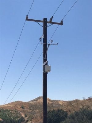
They do this by exploiting “real time” information culled from solar-powered weather station monitors attached to existing utility poles.
The utility has so far installed 29 solar-powered “weather stations” in high fire risk areas across Southern California, including four installed in the SCV in the last couple of weeks.
“Our goal is to have 125 in place in L.A. and Orange Counties,” Don Daigler, Edison’s director of business resiliency, said Friday.
Fire officials issue red flag warnings when critical fire weather conditions are occurring – or are about to occur – that involve high winds, low humidity and warm temperatures.
Edison’s solar-powered pole-mounted weather sensors and high-resolution cameras promise to reveal red flag situations faster and more accurately.
Edison meteorologists receive vital red flag information every 10 minutes from the devices they placed strategically in the wilderness including data on wind speed, wind gusts, temperature, humidity and solar radiation.
The comprehensive “real time” high-resolution monitoring of weather in the wild world around us does not stop there.
High-resolution cameras set up in fields, valleys and hilltops are expected to pepper all of Southern California — including the SCV.
The live feed of wilderness will be accessible online.
“The cameras can pinpoint a fire almost immediately,” Daigler said.
If an arsonist sets fire to a remote hillside, the well-placed cameras might just be able to capture that image.
Red flag data supplied by the weather stations and remote cameras is crunched by meteorologists at Edison’s Situational Awareness Center and by officials manning its 24-7 Emergency Operations Center, the utility’s nerve center.
The whole point of coming up with a high-tech weather model was to enhance fire prevention and public safety, Daigler said, by enabling firefighters to respond faster and with more advanced warning in snuffing out brush fires quickly.
“Our goal here is to forecast far enough in advance so that we can posture ourselves appropriately,” he said.
“If we can get a forecast five or seven days out, it gives us enough time to move resources in place,” he said.
“So when a bad situation happens, we’re prepared and able to respond.”
The utility would be able to shut off power, for example, during extreme weather conditions such as lightning strikes and high winds, protecting those in high fire risk areas.
661-287-5527
On Twitter
@jamesarthurholt