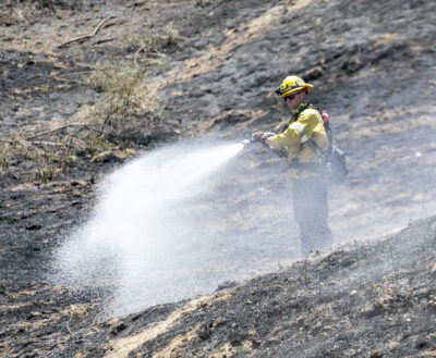
Despite another day of extreme winds, a joint effort between the Angeles National Forest and L.A. County firefighters kept the Hughes Fire relatively in check Thursday, according to U.S. Forest Service officials, as the evacuation orders were largely lifted.
After growing from 50 acres in size to approximately 8,000 acres in just a few hours by Wednesday afternoon, the fire was reported at 10,176 acres and 14% containment Thursday morning.
By Thursday evening the containment percentage had doubled, and the acreage burned kept to 10,278 acres, Celeste Morales, public information officer for the Angeles National Forest, said in a phone interview.
“Although we were expecting extreme fire behavior with heavy winds, our firefighters were able to hold the fire at where it’s at and then just trying to secure those edges,” she said, adding the focus is on increasing the perimeter firefighters have established around the brush fire.

The fast-moving brush fire near Castaic Lake burned thousands of acres in just a matter of hours on Wednesday and forced over 30,000 evacuations from nearby areas.
By Thursday morning, the evacuation orders had started to become warnings, then they were lifted altogether, thanks to firefighters’ efforts throughout the night. But firefighters remained extremely concerned as the forecast for Thursday called for winds expected to exceed 45 mph.
“The fire did lay down a bit overnight, but we did still have some areas that were flaring up, and we did have some swap-over in one of the areas as well,” said Jake Rodriguez, public information officer with the U.S. Forest Service. “So, we’re still actively engaged in a firefight. It’s not over yet.”
The fire burned through areas of the northeast side of Castaic Lake, initiating evacuation orders and warnings, some of which remained as of Thursday evening, although most have been downgraded to evacuation warnings. For updates on evacuation orders, visit bit.ly/3E78Ngj.

Overnight, water-dropping helicopters continued to battle the fire after fixed-wing aircraft operations were suspended due to darkness Wednesday. By approximately 2:15 a.m. Thursday, the helicopters were released because the flames had diminished to the extent that no additional drops were needed at that time.
Air operations resumed Thursday morning, however, as winds picked up and some new fire activity was reported within the burn area.
A total of 4,000 firefighting personnel with the Los Angeles County Fire Department and Angeles National Forest have battled the blaze.
No structures remained threatened and none were impacted as of Thursday morning, and no injuries have been reported, according to Fred Fielding of the L.A. County Fire Department.

Rodriguez also said a large amount of aerial support remained available in case the wind gusts, which were expected to reach 40 to 60 mph Thursday, caused any additional flareups.
“We have a lot of air resources committed to it, about 20 helicopters,” he said Thursday morning, in anticipation of the winds. “We have another 14 fixed-wing aircraft in the general region, not necessarily assigned just to this fire, but available for this fire to support other fires in the area as well.”
U.S. Forest Service officials announced Thursday evening the entire Angeles National Forest and San Gabriel Mountains National Monument are “temporarily closed for public safety and the protection of natural resources” through Jan. 31, according to a release sent by Dana Dierkes, public affairs officer for the Angeles National Forest.
At 11:29 a.m. Thursday, the Sheriff’s Department announced the following changes to emergency orders: Eight Zones moving from Evacuation Orders (Red) to Evacuation Warnings (Yellow):
- US-CA-XLA-CAS-PARADISERANCH
- US-CA-XLA-CAS-BISCAILUZ
- US-CA-XLA-CAS-RIDGE
- US-CA-XLA-LAC-E029
- US-CA-XLA-LAC-FRANCISQUITO
- US-CA-XLA-SCL-KELLYJOHNSON
- US-CA-XLA-SCL-REYESADOBE
- US-CA-XLA-SCL-STERLING
- US-CA-XLA-SCL-TESORODELVALLE
Twenty-seven zones moving from Evacuation Warning (Yellow) to Normal (White):
- US-CA-XLA-CAS-CAMBRIDGE
- US-CA-XLA-CAS-GOLDENSTATE
- US-CA-XLA-CAS-GREENHILL
- US-CA-XLA-CAS-HASLEY
- US-CA-XLA-CAS-HILLCREST
- US-CA-XLA-CAS-INDUSTRY
- US-CA-XLA-CAS-LIVEOAK
- US-CA-XLA-CAS-OAKCANYON
- US-CA-XLA-CAS-ROMERO
- US-CA-XLA-CAS-SLOAN
- US-CA-XLA-CAS-VALVERDE
- US-CA-XLA-GOR-E004
- US-CA-XLA-GOR-HUNGRYVALLEY
- US-CA-XLA-LAC-E005
- US-CA-XLA-LAC-E009-B
- US-CA-XLA-LAC-E011-A
- US-CA-XLA-LAC-E017
- US-CA-XLA-LAC-E018
- US-CA-XLA-LAC-E030
- US-CA-XLA-SCL-BLACKPINE
- US-CA-XLA-SCL-CALEX
- US-CA-XLA-SCL-DECORO
- US-CA-XLA-SCL-MOUNTAINVIEW
- US-CA-XLA-SCL-PACIFICCREST
- US-CA-XLA-SCL-RANCHOTESORO
- US-CA-XLA-SCL-RIONORTE
- US-CA-XLA-SCL-RYE
- US-CA-XLA-SCL-WESTHILLS
Perry Smith contributed to this report. This is a breaking news story, and additional information will be added as it becomes available.