For the sixth consecutive year, regional planners have granted a one-year extension to
developers who hope to one day build more than 500 homes between the eastern edge of the Santa Clarita Valley and Agua Dulce.
On Tuesday, a hearing officer for the Los Angeles County Department of Regional Planning approved a request made by the developer to have the project approval extended for at least one year.
For developer Matt Villalobos, the news was well-received.
“We’re gearing up to start construction next year,” he said Tuesday.
The Spring Canyon project has been in the works for 15 years, he said, noting there have been many map revisions in that time.
“We’re finally at that stage where all the plans are being approved,” Villalobos said. “We’re recording the final maps in the next couple of months.”
As hearing officers for the county Department of Regional Planning reviewed this year’s request they were reminded that this is the “sixth discretionary time extension.”
The approval gives Villalobos a green light to transform rural undeveloped land into subdivisions.
It calls for changes made to the Los Angeles Countywide General Plan converting land deemed “non-urban” to “low density residential” and changes to the Santa Clarita Valley’s Area Plan converting “non-urban” to “urban.”
Zoning changes are also in the works for “heavy agricultural” land to become “single-family residence.”
“The one-year time extension was approved by the hearing officer yesterday,” Mitch Glaser, spokesman for the Regional Planning Department, told The Signal on Wednesday.
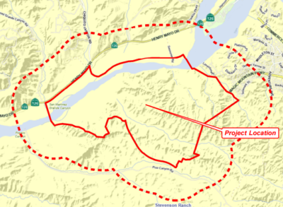
The planned housing development sits north of Highway 14 and Soledad Canyon Road, between Shadow Pines Boulevard and Agua Dulce Canyon Road.
It will mean 542 homes built, one Los Angeles County Fire Department station and one Los Angeles County Sheriff’s Department substation, two parking lots and three open space lots, all on nearly 550 acres.
It will mean grading a hilly terrain in compliance with “hillside management design criteria,” according to the documents reviewed Tuesday by regional planners.
The one-year time extension for the project is good until Aug. 3, 2019.
661-287-5527
on Twitter @jamesarthurholt