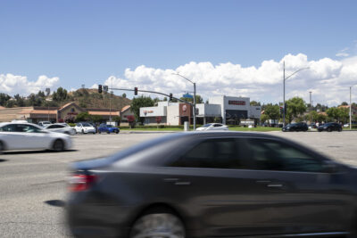
A few land swaps and compensation for property in the way are all that’s left for the city to take care of to clear a path from Highway 14 through Placerita Canyon to Newhall, opening another major east-west arterial for Santa Clarita, according to Tuesday’s City Council agenda.
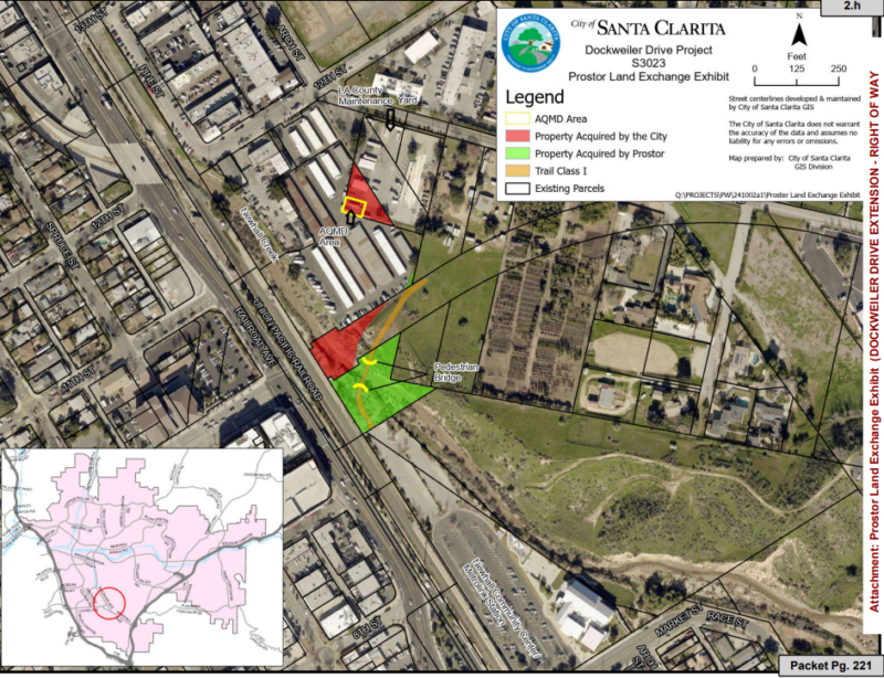
The final plan for the extension of Dockweiler Drive is expected to connect the road, which starts at Sierra Highway, through the southern end of The Master’s University and connect through Arch Street to 13th Street, according to maps provided by the city.
The land swaps are a part of 15 separate recommended actions, a total of 29 easements, changes to a number of traffic lights and even a shoutout to the Fair Political Practices Commission for advising the council on how to ethically and legally maneuver around a unique situation: a land swap involving a council member’s piece of land that’s considered critical for the road.

“Originally constructed in the early 1990s, Dockweiler Drive currently connects to Sierra Highway to the east and terminates 500 feet west of Valle del Oro to the west,” according to the city’s agenda for Tuesday.
The city’s General Plan designates Dockweiler Drive as a “secondary highway,” which has an ultimate design of four travel lanes, designed to service both through traffic and to collect traffic from collector and local streets.
The agenda considers the path an important part of the city’s five-year strategic plan, Santa Clarita 2025.
The work is also vital to the master plan for The Master’s University, which is a major property owner in the canyon. Accordingly, TMU is expected to pay for a portion of the work through its property in partnership with the city.
Questions have been raised about the unusual nature of the deal with respect to the negotiating parties involved in one of the 15 recommendations: Councilwoman Laurene Weste, who’s been a member of the City Council since 1998, and Santa Clarita, are involved in a land swap.
Weste is paying $17,000 to the city for the difference in the assessor’s evaluation for the land she’s giving up versus what she’s getting from the city. The land swap, which involves partial parcels, is identified in the map the city provided.
The city mentioned a consultation with the FPPC in response to a potential conflict:
Weste “is required by state law to recuse herself from making, participating in the making, or otherwise using her official position to influence any of the city’s decisions on the Dockweiler Drive Extension project, as the project directly affects her real property,” according to the agenda. It also states the city “would not be permitted to enter into an agreement with Ms. Weste while she is a council member,” absent of an exception.
However, an exception was found.
“On Aug. 27, 2021, the California Fair Political Practices Commission (FPPC) determined that an exception applies in this situation to permit the city to enter into an agreement with Ms. Weste because the acquisition of a portion of her property is necessary for the project, provided that Ms. Weste’s involvement in this matter is limited to communications with the city in her individual capacity and as a landowner,” according to the agenda’s summary of the FPPC ruling.

“Discussions and negotiations between the city and Ms. Weste, in her private capacity and as a landowner, have occurred between her, her attorney, city staff, and the city’s special counsel for this project,” according to the city.
In addition to the land she’s receiving in the deal, Weste currently owns about 7.5 acres of property surrounding the land she’s swapping, which is zoned for mixed-use development.
Weste is paying a dividend for the land swap because the assessed value of the land she’s getting is more than the land she’s giving the city. But her largely vacant land is sure to increase significantly once the surrounding infrastructure is in place, according to those familiar with the area.
“The value of a property definitely has a substantial portion of it that is decided from what it already has in place, infrastructure-wise,” said Vincent Michael Durso, a licensed real estate agent with Realty ONE Group Success in Valencia. Durso represents several properties in the area, including one by Dockweiler Drive and Sierra Highway.
The second thing, he added, is the old Realtors’ adage: location, location, location. Its proximity to other development is a factor.
The 1.79-acre property he represents near Dockweiler Drive and Sierra Highway is listed for $1.7 million, he said.
“If you have the street frontage, and you have the water and the power already there, you’re going to be in a lot better position than you would be if you’re up in the sticks where you don’t have it,” said Durso, who also represents a 5.9-acre property at Sierra Highway and Newhall Avenue, another prime lot, listed for $5 million. “(If) you don’t have the road, you have to bring in all the infrastructure — you’re talking about an extreme amount of money that that’s going to cost for that infrastructure.”
The city is also swapping land for easements with a Newhall property owner, a deal that is expected allow the city to create a Class 1 bike and pedestrian trail and bridge from Dockweiler to the Newhall Community Center parking lot.
The original timeline given for the Dockweiler project, which initially was thought to begin in December, was approximately two years.
The latest addendum to the Dockweiler Drive plans are also detailed in the agenda:
The city environmental impact report addendum evaluated the addition of the following “Modified Project,” constituting changes from the originally approved project EIR:
• A roundabout at 12th Street and Arch Street and signalized “T” intersection at Dockweiler Drive and Placerita Canyon Road.
• Railroad Avenue median modifications and dedicated right-turn pedestrian refuge island from 13th Street to Railroad Avenue.
• A Class I bicycle and pedestrian pathway and bridge south of Dockweiler Drive, spanning Newhall Creek and connecting to the Jan Heidt (Newhall) Metrolink Station and Newhall Community Center parking lot.
• Two basins to capture and treat stormwater; one interim detention basin and conveyance located on the north side of 13th Street and east of the railroad tracks and one infiltration basin located south of the improvements at Placerita Canyon Road.
• Union Pacific and Metrolink Railroad reprofiling approximately a quarter-mile of the railroad line and grading improvements.
• Property acquisition and/or easements of up to 29 properties (10 more than the 19 identified in the EIR).
• Removal of two additional oak trees (four total) and encroachment on eight oak trees.
• A larger grading footprint of approximately 7 acres (2 acres more than the 5 acres identified in the EIR) on the northern portion of the project site to accommodate roadway and intersection improvements, grading improvements along the railroad line, and the two stormwater basins.
• A longer grading period of up to 18 months (12 months were identified in the EIR).