By Jack Phillips
Contributing Writer
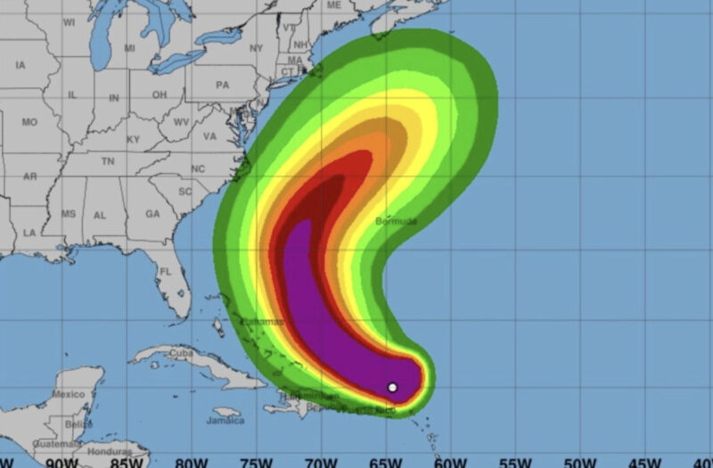
Hurricane Erin is expected to increase in size over the coming days, prompting federal officials to issue a tropical storm watch for coastal areas in North Carolina on Tuesday morning.
Erin, which has Category 2 winds of 110 mph, is still not expected to make landfall anywhere, including the United States, according to forecasters. The storm on Tuesday was located about 665 miles southwest of the island of Bermuda and around 720 miles south-southeast of Cape Hatteras, North Carolina, but it is anticipated to move to the north and then northeast by later this week as it crosses over the northern Atlantic Ocean.
The tropical storm watch for North Carolina extends from Beaufort Island to the town of Duck, which includes the Pamlico Sound, officials said. A storm surge watch was issued for Cape Lookout to Duck, North Carolina, the U.S. National Hurricane Center said in its latest advisory posted at 8 a.m. ET on Tuesday.
Tropical storm conditions and heavy flooding are expected in the Outer Banks of North Carolina, a popular tourist area, starting on late Wednesday or Wednesday night, the NHC said. Officials in the state’s Dare County issued a bulletin earlier this week due to Erin, with the entire county remaining under a state of emergency.
Tropical storm warnings are in effect for the Turks and Caicos Islands and the southeastern portion of the Bahamas, according to the NHC. A tropical storm watch was issued for the central Bahamas.
A tropical storm watch means that tropical storm conditions could occur within the next 48 hours, while a warning means that conditions are expected somewhere within the NHC’s warning area.
“There is not much change to the track forecast reasoning, with the hurricane still expected to recurve over the western Atlantic” between the East Coast of the United States and Bermuda over the next three to four days, the NHC said in a discussion.
Because the storm is large and growing in size, the NHC’s latest forecast “now brings tropical-storm-force winds very close to the Mid-Atlantic and southern New England coast later this week,” it said.
As a result, Erin is expected to bring “life-threatening surf and rip currents” in Bermuda, the Bahamas, the East Coast of the United States, and Canada’s Atlantic coastal areas over the coming days, the NHC said.
Before it weakened, Erin had strengthened into a Category 5 system, with 160 mph winds, by Saturday. The storm’s strength fluctuated over the weekend, rising on Saturday to Category 5 before dropping back to Category 4 late on Sunday, before it weakened into a Category 3 on Monday and a Category 2 on Tuesday.
Aside from Erin, NHC forecasters are monitoring a tropical disturbance in the eastern portion of the Atlantic that appears to be following the hurricane’s initial footsteps.
The disturbance has a 60% chance of forming into at least a tropical depression over the next seven days, while it has a 10% formation chance in the coming 48 hours, the NHC said on Tuesday.
“A tropical wave located over the central tropical Atlantic continues to produce a broad area of disorganized showers and thunderstorms. Environmental conditions appear conducive for gradual development of this system, and a tropical depression could form toward the end of the week or this weekend,” the center said.
The developing system is expected to move toward the west and northwest at around 20 mph before it approaches near the Leeward Islands, which separate the Atlantic Ocean and Caribbean Sea, by Friday, said the NHC. After that, it’s not clear where the system is expected to go.