By Jack Phillips
Contributing Writer
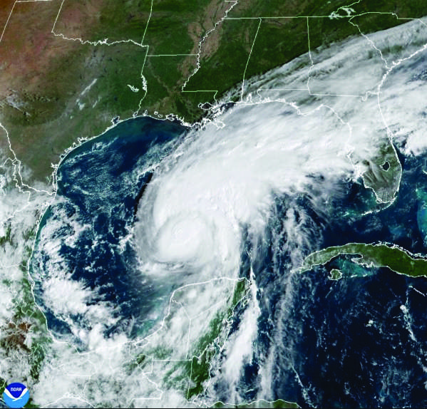
U.S. weather forecasters on Friday morning said Hurricane Isaias has become a Category 3 major storm with 120 mph winds — with just hours to go before it was expected to make landfall along the northern Gulf coast.
An update posted at 8:20 a.m. ET by the National Hurricane Center, citing new data sourced from hurricane-monitoring aircraft, showed the storm about 240 miles south of Pensacola, located on Florida’s Panhandle region, and 170 miles south-southeast of the mouth of the Mississippi River.
The storm was moving 15 mph to the north-northeast, according to the NHC. A forecast map showed that the storm was expected to strike land sometime between late Friday night and early Saturday morning, likely along the Florida-Alabama border.
Hurricane warnings were issued by the NHC from Ocean Springs, Mississippi, to the Bay-Gulf county lines in Florida. Storm surge warnings were issued for the mouth of the Mississippi River to the Suwannee River.
Tropical storm warnings were in effect for the Jefferson-Plaquemines parish line in Louisiana to west of Ocean Springs, Mississippi, as well as from east of the Bay-Gulf county lines in Florida to the Aucilla River in Florida. Storm surge watches were issued from the Suwannee River to Yankeetown, Florida, the agency said.
Hurricane and tropical storm warnings mean that either hurricane or tropical storm conditions, respectively, are expected in the warning areas. Meanwhile, storm surge warnings mean there is a danger of life-threatening flooding moving inland from the coastline.
Inland, the storm is expected to produce somewhere between 4 and 8 inches of rain in southern Alabama, the Florida Panhandle and Big Bend area, and southwestern Georgia. Localized totals of 15 inches may occur in some areas, namely in Florida’s Panhandle and Big Bend areas as well as southwestern Georgia, forecasters said.
The remainder of the southeastern United States is expected to get around 2 to 5 inches, the NHC said, while flash or urban flooding is likely across the region. Potentially significant river flooding is also being forecast in the region, it added.
Officials advised residents to make final preparations before the storm makes landfall due to the potentially life-threatening storm surge, winds and flooding.
Category 3 storms, which the NHC describes as a major hurricane, are capable of causing devastating damage, according to the weather agency’s Saffir-Simpson wind scale.
“Well-built framed homes may incur major damage or removal of roof decking and gable ends,” the agency says on its website, describing the possible outcome of a Category 3 system. “Many trees will be snapped or uprooted, blocking numerous roads. Electricity and water will be unavailable for several days to weeks after the storm passes.”
Isaias was expected to weaken quickly as it hits shore and be downgraded to a tropical storm by Saturday afternoon as it moves north and inland along the Alabama-Mississippi line, the center’s forecasting models show.
The governors of Alabama, Florida and Georgia have all declared emergencies in anticipation of Isaias.
In his order on Thursday, Georgia Gov. Brian Kemp warned the storm could spawn tornadoes across his state, alongside downed trees and power lines, as well as flooding.
“As we always do with weather events, we’re hoping for the best but preparing for the worst,” Kemp said in a statement advising residents to take Isaias “seriously and prepare now by stocking up on food, batteries, flashlights, water, and other necessities in case of severe weather impacting communities Friday night through Saturday.”
Florida Gov. Ron DeSantis on Thursday also confirmed that he was activating 5,000 members of the state National Guard ahead of the storm.