
By Owen Evans
Contributing Writer
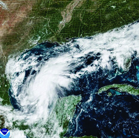
Tropical Storm Isaias formed over the southwestern Gulf of America on Wednesday and is forecast to rapidly turn into a hurricane before reaching the U.S. Gulf Coast later this week, according to federal forecasters.
The National Hurricane Center forecasts Isaias to become a hurricane by Thursday and reach peak sustained winds of about 110 mph on Friday before moving inland and weakening.
At 110 mph, the storm would be just below Category 3 strength, which begins at 111 mph.
The Weather Channel reported on Tuesday that Isaias is “expected to strengthen into the first hurricane of the season in the Atlantic.” It added that Isaias is the ninth named storm of the 2026 Atlantic hurricane season.
Florida Gov. Ron DeSantis warned that the Panhandle could be impacted by Isaias.
“Even if it makes landfall west of the panhandle, the eastern, most dangerous side [of] the storm will impact NW Florida,” DeSantis said in an Oct. 7 post on X.
“If you are in those communities make sure to execute your hurricane plan,” he added.
Earlier Wednesday, DeSantis signed Executive Order 26-202, declaring a state of emergency for 25 counties in preparation for the storm, which at the time was designated Tropical Depression Nine.
DeSantis said the order would give communities sufficient time and resources to prepare for potentially severe weather.
Senator and former Florida governor Rick Scott wrote on X on Tuesday that Isaias has the “potential to be a very serious storm.”
“I’ll be in Pensacola tomorrow working with local leaders and emergency management officials to make sure families are prepared. Everyone should take this seriously — make a plan NOW!” he said.
The Hurricane Center said Isaias should be “growing in size as it approaches the northern Gulf coast due to a trough interaction.”
It was expected that hurricane and storm surge watches would likely be required for portions of the northern Gulf Coast later Wednesday.
Isaias is also expected to bring heavy rainfall to the central Gulf Coast and much of the Southeast from Friday into the weekend, raising the risk of flash flooding, urban flooding and isolated river flooding.
Before reaching the United States, the storm is expected to strengthen while passing near the western portion of Mexico’s Yucatan Peninsula, where gusty winds and heavy rain are possible over the next day or two.
The Miami-based hurricane center said Isaias is expected to produce 2 to 4 inches of rain through Thursday across coastal areas of the Bay of Campeche, with isolated higher totals possible in Campeche state and western Yucatan.
From Friday through the weekend, rainfall totals of 3 to 6 inches are forecast across the northern U.S. Gulf Coast, stretching from far southeastern Louisiana to the Florida Panhandle. Localized totals could reach 10 inches, it said.
Much of the Southeast could receive 1 to 3 inches, with local areas receiving up to 5 inches extending as far north as the Tennessee Valley and the Carolinas.
The National Weather Service office in Tallahassee said in an Oct. 7 post on X that Isaias is expected to approach major-hurricane status before nearing the Gulf Coast on Friday.
It warned that the storm could produce heavy rain, damaging winds, tornadoes, and storm surge, particularly along and east of its center.
The agency said the 5 a.m. advisory showed a slight eastward shift in the projected track and a somewhat stronger storm than earlier forecasts.
Most impacts across the northeast Gulf Coast are expected from Friday into Saturday or Sunday, it said.