CHP officers warn drivers to slow down amid wet conditions
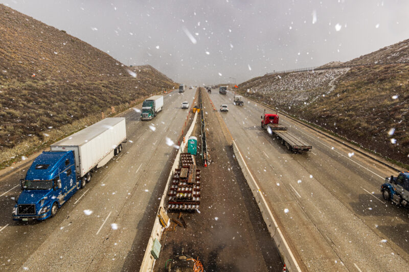
The California Department of Transportation issued a traffic advisory warning drivers of heavy snowfall on the Grapevine since 2 a.m. and prompted the closure of Interstate 5 going north at Lake Hughes Road.
In addition, California Highway Patrol officers are asking drivers to slow down to prevent further traffic incidents amid a winter storm affecting Southern California, including the Santa Clarita Valley.
“We have had a couple crashes, the rain and snow make it more challenging for the motoring public,” wrote CHP Officer Josh Greengard, spokesman for the CHP’s Newhall Office, in a statement to The Signal. “These crashes could have been avoided by slowing down.”
Greengard also noted CHP and Caltrans are utilizing the snow gate on the northbound lanes of Interstate 5 to turn vehicles around. He advised the drivers to either wait for the weather to improve or to take alternate routes.
🚨TRAVEL ADVISORY🚨
— Caltrans District 7 (@CaltransDist7) February 24, 2023
❄️OPERATION SNOWFLAKE❄️@CHPFortTejon & Caltrans have CLOSED I-5 through the Tejon Pass from a Grapevine Rd to Parker Rd. Closure duration unknown. US 101 is the alternate route. Limit your non-essential travel! See closures at https://t.co/cxZ0jW7S5n. pic.twitter.com/ZhY2R8ruto
“The motoring public can do both. This storm may be here awhile,” Greengard wrote in the statement to The Signal. “The best alternate route would be the 126 west to the northbound 101 freeway.”
At noon, Caltrans shared via Twitter images of crews dealing with snow along a 20-mile stretch of the I-5 south to Templin Highway near Castaic.
“Over a foot of snow has fallen at some of the corridor’s highest elevations,” read Caltrans Twitter post.
As of 1 p.m., Caltrans had no estimated time of reopening the I-5.
According to Greengard, snow was a possibility during the early morning hours of Friday on Highway 14 and may have resulted in road closures. However, that possibility was washed away due to “heavy rain.”
The city of Santa Clarita issued its own alert at approximately 9:56 a.m. asking residents to avoid all Arizona crossings along Placerita Canyon Road and Sand Canyon Road due to fast-moving water. The city also announced Whitney Canyon and Towsley Canyon would be closed due to storm conditions.
Meteorologist David Gombert, with the National Weather Service’s Oxnard Station, said SCV residents can expect a high of 47 and a low of 40 in the night.
“So, not quite as cold as it has been because the snow levels are lifting a little bit,” Gombert said. “We have some pretty strong southerly winds that we’ll keep. It’s going to be chilly with the wind, but the actual air temperatures will be slightly higher tonight as the snow levels rise a little bit.”
He noted as of 11 a.m., the SCV saw about a half an inch to 1 inch of rain, an average across the valley — with about 3 to 5 inches of rain expected from this storm system.
“The worst is still yet to come,” he said. “It’s going to rain on and off all day today, and then tonight we’ll see the worst part both in terms of the strongest wind and highest rain.”
Lastly, he said the SCV shouldn’t expect to see any snow on the valley floor as snow levels rose between 4,000 to 5,000 feet of elevation. On Saturday, snow levels will drop down between 2,500 to 2,000 feet of elevation, still above the valley floor elevation.
Advisories from the National Weather Service
The National Weather Service issued the following in response to the hazardous weather conditions:
- A flood watch in effect from Friday at 10 a.m. until Saturday at 6 p.m.
- A wind advisory until Saturday at 1 a.m.
- A flood advisory until Friday at 4 p.m.
- A flash flood warning until Friday at 10 p.m.
An emergency alert was issued from the National Weather Service Friday afternoon.
“This is a dangerous and life-threatening situation,” read the emergency alert. “Do not attempt to travel unless you are fleeing an area subject to flooding or under an evacuation order.”
Also on Friday afternoon, the Los Angeles County Sheriff’s Department issued a Nixle warning of the flood watch issued for the SCV. The Nixle stated that if residents receive a CodeRED phone call, to listen carefully to the entire message and to not call 9-1-1 unless directed to do so or if need of immediate aid. The same goes for CodeRED text messages.
The flood watch will last until Saturday afternoon.