By Jack Phillips and Melanie Sun
Contributing Writers
As Hurricane Erin continues to churn across the Atlantic Ocean, the National Hurricane Center said on Monday that a tropical disturbance that appears to be following in the hurricane’s path has a chance of developing into a stronger storm within the next week.
The NHC said that the disturbance, which is described as a “tropical wave,” is “producing disorganized showers and thunderstorms.”
“Environmental conditions appear conducive for gradual development of this system, and a tropical depression could form during the latter part of the week,” the agency said in a bulletin.
“This system should move westward to west-northwestward at about 20 mph across the central tropical Atlantic and approach the vicinity of the Leeward Islands toward the end of the week.”
The disturbance has a very low formation chance through the next two days, but has a 50% chance of formation through the next seven days, according to the NHC.
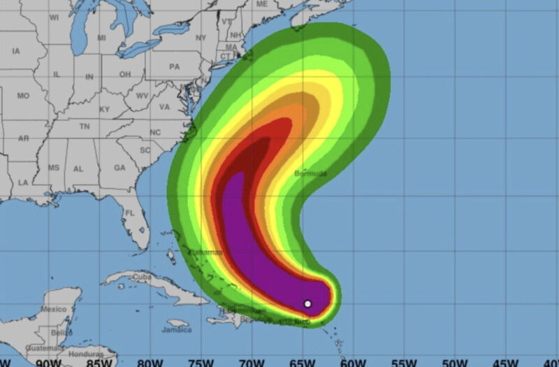
Federal officials say that Erin strengthened into a major Category 4 hurricane with 130 mph winds. However, the storm is not expected to make landfall in the United States and is expected to remain hundreds of miles away from the East Coast before passing north and to the east over the Atlantic Ocean before dissipating.
No hurricane warnings or watches have been issued anywhere, but tropical storm warnings were issued for the southeastern Bahamas as well as the Turks and Caicos Islands, according to the agency. Tropical storm watches have been issued for the central Bahamas.
“Despite the path of Erin forecast to remain offshore, the threat of life-threatening rip currents, damaging beach erosion, major coastal flooding and overwash, and extremely dangerous surf continues to increase,” the NHC said in a briefing issued Monday.
Erin is also anticipated to increase in size, producing impacts along the East Coast. Tropical storm-force winds could hit the Outer Banks area in North Carolina as the size increases, it said.
Coastal flooding could occur around high tide starting Tuesday and could peak on Wednesday and Thursday, it said. Parts of the Outer Banks, the NHC added, could be inaccessible for several days due to the flooding, known as ocean overwash.
The storm prompted officials in Dare County, North Carolina, to issue a state of emergency across the county, which includes the Outer Banks. A mandatory evacuation order was also issued for Hatteras Island, located off the state’s coast, due to overwash and flooding.
“Severe flooding will likely extend inland, where there is vulnerable or no protective dune structure, flooding homes and businesses, with some structural damage possible. Roads will likely be impassable under several feet of water, and vehicles will likely be submerged,” the county’s emergency management office said on Sunday evening.
Early Monday, Erin was located about 115 miles north-northeast of Grand Turk Island and about 890 miles south-southeast of Cape Hatteras, North Carolina. It was moving northwest at 13 mph, forecasters say.
Erin’s outer bands pelted parts of Puerto Rico and the Virgin Islands with heavy rain and tropical-storm winds on Sunday.
The Atlantic hurricane season started on June 1 and will end on about Nov. 30. Generally, the peak activity for hurricanes in the Atlantic is typically between mid-August and early October.
Erin downgraded, but growing
Hurricane Erin was downgraded Sunday, although it was growing in size after it spent Friday night and Saturday transforming from a tropical storm into a Category 5 hurricane, the NHC said in updates.
Late Saturday into early Sunday, Erin’s wind speeds were reported to have eased, leading to the downgrade to a Category 4 and then Category 3 storm, as the system passed over the northern Leeward Islands, the Virgin Islands, and Puerto Rico, according to a 2 a.m. ET update.
Wind speeds remained formidable, with maximum sustained speeds coming in at 125 mph, down from 160 mph, the Miami-based NHC said.
A Category 4 storm has the potential to cause “catastrophic damage,” while a Category 3 storm — with windspeed between 111 to 129 mph — has the potential to cause “devastating damage.”
The National Weather Service in San Juan had issued an alert for Saturday night for nearly two-thirds of Puerto Rico, warning of 50 mph winds. Power was knocked out to about 130,000 customers in the territory.
Despite the downgrade, the forecaster said that Erin is in the process of growing to become “a larger system.”
This matched the center’s earlier 11 p.m. assessment. “A recent scatterometer pass indicates that Erin’s outer-core is growing in size, and the models remain in strong agreement that the system will grow further the next several days,” it said.
“In fact, by the middle of next week, Erin is forecast to at least double or triple in size, which will result in rough ocean conditions over the western Atlantic.”
Fluctuations Expected
“Fluctuations in intensity are expected over the next day or two due to inner-core structural changes,” the NHC added in its 2 a.m. update.
“Hurricane-force winds extend outward up to 25 miles (35 km) from the center and tropical-storm-force winds extend outward up to 205 miles (335 km).”
The forecaster said that the tropical storm watches for St. Martin, St. Barthelemy, and Sint Maarten had been lifted.
As a precaution, the federal government has deployed more than 200 employees from the Federal Emergency Management Agency and other agencies to prepare for the storm. Officials in the Bahamas also prepared shelters and urged people to monitor the storm’s progress.
Erin is the first hurricane of the season to reach Category 5 wind speeds — earlier than is typical for the first half of hurricane season. The most powerful storms tend to form later in the year, with the season typically peaking in mid-September.
The Atlantic hurricane season is predicted to be busy this year, with six to 10 hurricanes forecast, including three to five expected to reach the major status of a Category 3.
The Associated Press contributed to this report.