The city of Santa Clarita offered the community an update on what it’s working on with Belcaro in Sand Canyon, a new housing development for residents 55 and older.
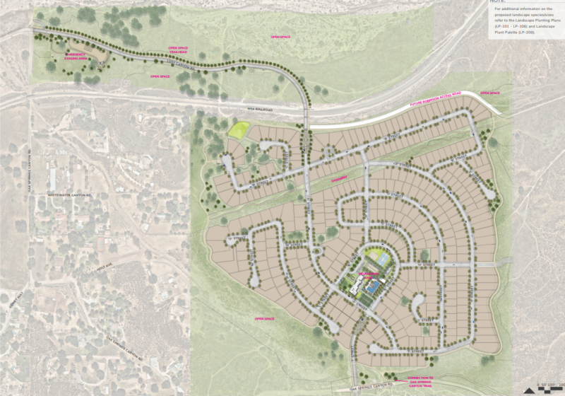
New Urban West — which is also involved in the proposed Sunridge project closer to the center of town, as well as several others — is planning 341 single-family senior homes on 193 acres east of Sand Canyon and Lost Canyon roads, north of Sand Canyon Country Club.
While city planners said the dirt roads surrounding the project weren’t yet suitable for a tour bus, the Planning Commission and public were offered a virtual site tour Tuesday from project planner Andrew Olsen.
The project is being designed around the train tracks in the area, according to Olsen.
North of the tracks would be the extension of Lost Canyon Road, as well as a proposed trailhead and an emergency staging area for equestrian purposes as well as open space, he said, and “south of the tracks would be the proposed development.”
The developer also is invoking a density bonus because the residential element is being used exclusively for senior housing.
There are several traffic adjustments called for in the project’s plans, which Olsen described.
Motorists will be able to access the site from Lost Canyon Road, connecting Sand Canyon Road to the proposed “A” Street on-site.
The existing Lost Canyon Road would be improved and extended to connect to the development with a proposed railroad undercrossing. The project would also improve the existing intersection of Sand Canyon Road and Lost Canyon Road with a roundabout.
The project calls for trail construction nearby, including an approximately 0.6-mile off-site trail along the northern side of Lost Canyon Road, which would connect to the project’s proposed on-site trail to Sand Canyon Road. An additional 0.3-mile trail would also be constructed on the west side of a new street proposed for the plan, which would connect the project’s proposed trail network to the off-site trails within Robinson Ranch to the southern portion of the project site.
The breakdown of land use for the project, according to planning documents, is 58.7 acres for the 341 homes, with 682 fully enclosed garage parking spaces and 537 unenclosed street parking spaces available. The maximum height for the homes is just under 28 feet.
There’s also a 3-acre recreation area and clubhouse being planned, in addition to about 22 acres of access and street improvements and 106 acres of open space.
The Planning Commission did not yet have a planned date for a hearing on the project, but one is expected in the coming months.